, 0°
Wind: mph

That’s right, cartographer. It’s a pretty fancy word, and I wasn’t one hundred percent sure I was using it properly, but when I checked online, I became sure …
Stay informed about your community and support local independent journalism.
Subscribe to The River Reporter today. click here
This item is available in full to subscribers.
Please log in to continue |

That’s right, cartographer. It’s a pretty fancy word, and I wasn’t one hundred percent sure I was using it properly, but when I checked online, I became sure enough—it’s “a person who draws or produces maps.” And amongst the many artistic endeavors Rocky had embarked upon during his storied career, cartography is now firmly on the list.
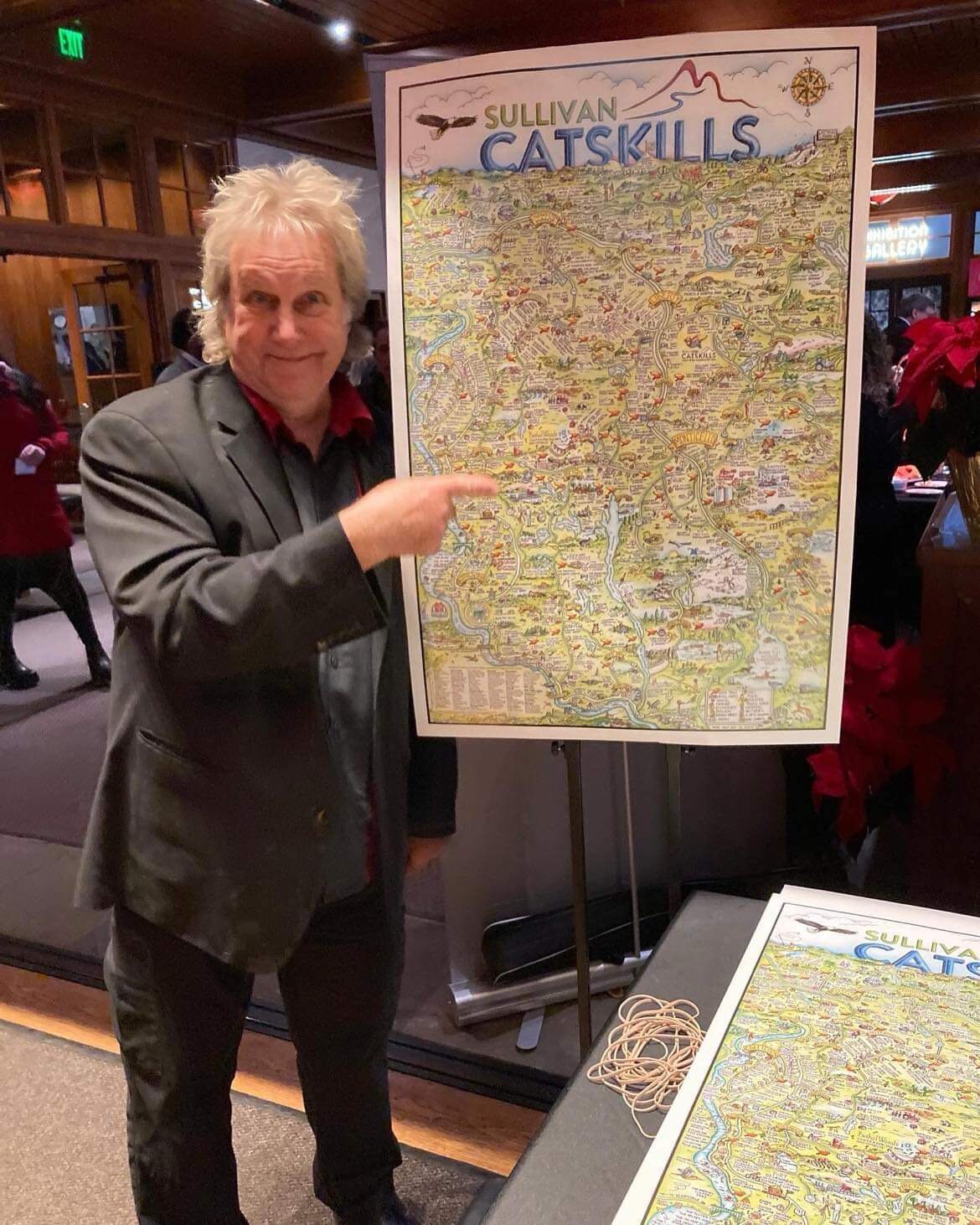
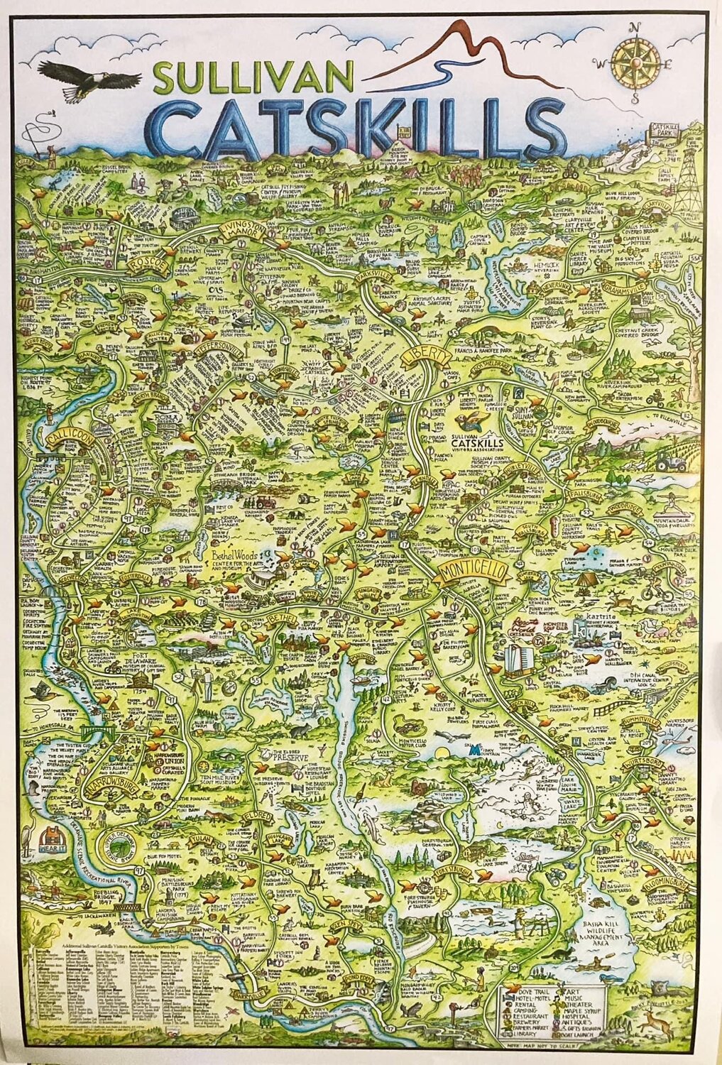
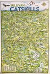
Pinciotti has dabbled with map-making in the past, but his latest—a hand-drawn, hand-colored map of Sullivan County created specifically for the Sullivan Catskills Visitors Association (SCVA)—is by far his largest and most ambitious cartography project to date.
Not only had I already seen the map, but I managed to snag a signed copy at the SCVA holiday party last month, and it’s pretty cool. I was fascinated with the finely lined, detailed little drawings and blown away by the sheer scope of it all.
So when I learned that the Narrowsburg Union would be hosting an “on-site talk and demo” with Rocky, who would be discussing his insanely creative, stylized map-making process, I jumped at the chance to hear how it all came about.
“I’ve dabbled in a lot of different mediums, but I always come back to drawing,” Pinciotti said by way of introduction—and apparently, it runs in the family. “I started in grade school. My dad was a decent painter. My uncle was also an artist and designed the logo for the Toledo Mud Hens, among other things. His son is a great graphic designer. I’ve always loved to draw.”
“As many of you know, I was the gallery director at the Delaware Valley Arts Alliance, and I did a little drawing for a plein air event after deciding that we needed a little map to help people navigate through it. Soon after, Tina Spangler asked if I could do a little map of Narrowsburg for the Big Eddy Film Festival, which really started it all.”
After that, the River Reporter came up with the notion to turn that map into a creative advertising project for the paper, which Rocky agreed to do. Following that, the town of Roscoe approached him about creating a map for them, and again, Pinciotti agreed.
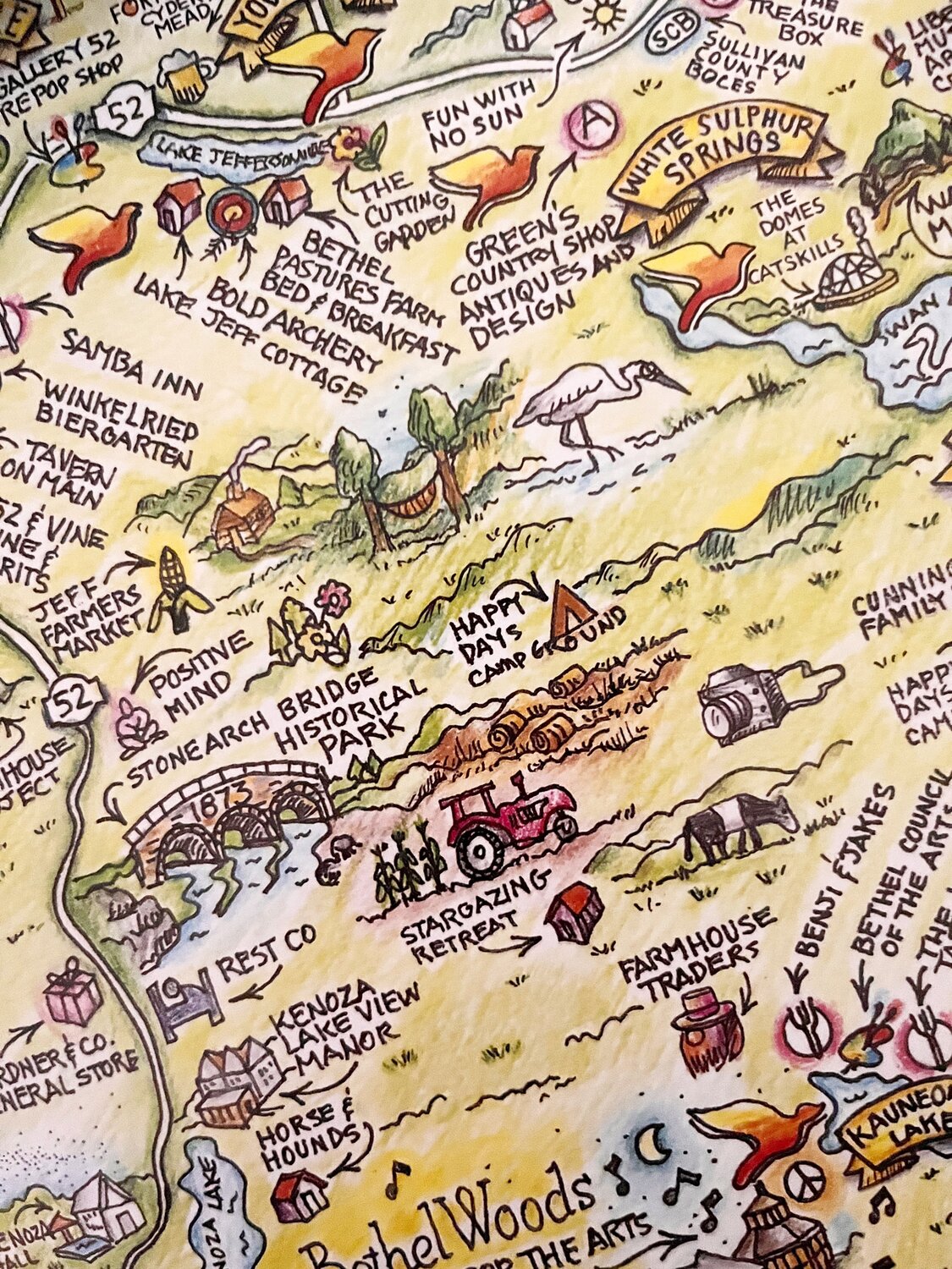
“For that project, I was asked to identify the various buildings, which was the first time I employed little arrows. And that map was used for the town brochure, which was then picked up by the folks at the Roscoe diner, who turned it into placemats,” he said.
“Then COVID happened. We didn’t go anywhere, just stayed home, and I started to draw and draw and draw. If I woke up in the middle of the night, I would draw. I didn’t have to get up in the morning, so I could stay up and just draw all night. I’d do whole pages of line drawings on one subject: screwdrivers, monkeys, sea shells, cookies. It was fun. I didn’t worry about mistakes. I like to see mistakes.”
“I had done a map for a RiverFest poster, which I really liked and was well received. It was simple, with a few little landmarks—pretty, but not too complicated. That led me to a conversation about a county-wide map with SCVA CEO Roberta Byron-Lockwood, who liked the idea and took it to her board. Once we were all in agreement, the journey really began.”
“It’s all hand-drawn. My tools are a micron pen, a felt tip pen, color pencils and a sharpener. The line drawings are not really that intricate and it’s the colored pencil that makes the drawing pop. It’s almost like a coloring book.
“It was a complex project,” Pinciotti shared with the room. “I had to decide what colors and hues to use for different locations, and create a method to remember them all. There were a lot of details, including keeping track of the doves. It required attention to continuity for the map to make sense.”
Sullivan County encompasses 997 square miles, much of which is open land, and the map had to include 700 businesses and 70 of those colorful SCVA doves dotting the landscape.
“I put a lot of miles on the car. Who knew there was an actual Pleasure Lake or Lovers Lane in Sullivan County? Part of making the map was discovering all that fun stuff along the way.”
Months passed as Pinciotti stayed up late into the night drawing, drawing, drawing. New businesses became SCVA members, while some others dropped off the map.
“There were several iterations. We’d sit down periodically with the spreadsheets at the SCVA and make sure the map was up to date. At some point, we had to stop making changes, and I had a final draft of the black-and-white line drawing printed, took it home and began to color it.”
All told, the process took 18 months for Pinciotti to complete, and the end result—a hand-drawn; insanely detailed; clever, clever map of Sullivan County—has been captivating crowds since its debut just last month. There are “Easter eggs” (fun little hidden gems) embedded in the map, along with a few personal winks and nods that have folks comparing notes.
Rumors of a future puzzle are whispered in the halls of the Narrowsburg Union, where prints of Rocky Pinciotti’s Sullivan Catskills map are available at Catskills Curated. You might even be able to persuade the cartographer to sign one! For more info, visit www.catskillscurated.com.


Comments
No comments on this item Please log in to comment by clicking here