 Narrowsburg
Light Rain Fog/Mist, 43°
Wind: 8.1 mph
 Narrowsburg
Special Weather Statement Special Weather Statement from the National Weather Service Binghamton NY 139 PM EDT TUE MAY 15 2018 NYZ057-062-PAZ039-040-151830- Sullivan NY-Delaware NY-Susquehanna …
Stay informed about your community and support local independent journalism.
Subscribe to The River Reporter today. click here
This item is available in full to subscribers.
Please log in to continue |
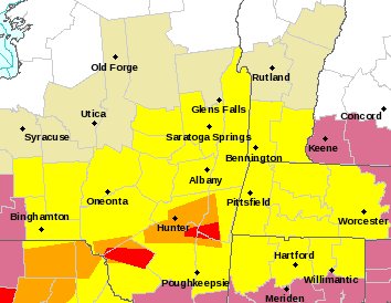
Special Weather Statement from the National Weather Service Binghamton NY 139 PM EDT TUE MAY 15 2018 NYZ057-062-PAZ039-040-151830- Sullivan NY-Delaware NY-Susquehanna PA-Northern Wayne PA- 139 PM EDT TUE MAY 15 2018 ...A LINE OF STRONG THUNDERSTORMS WILL AFFECT...SOUTHWESTERN DELAWARE...NORTHWESTERN SULLIVAN...CENTRAL SUSQUEHANNA AND NORTHERN WAYNE COUNTIES UNTIL 230 PM EDT... At 139 PM EDT, Doppler radar was tracking strong thunderstorms along a line extending from near Sherman to Rush. Movement was east at 45 mph. Half inch hail and winds in excess of 40 mph will be possible with these storms. Locations impacted include... Rockland, Rush, Jackson, Susquehanna, Susquehanna Depot, Montrose, Dimock, Harford, Hallstead and Hancock. These storms may intensify, so be certain to monitor local radio stations and available television stations for additional information and possible warnings from the National Weather Service. A Tornado Watch remains in effect until 800 PM EDT for central New York...and northeastern Pennsylvania. Additional statements will be issued as conditions warrant. LAT...LON 4174 7519 4175 7612 4200 7587 4202 7478 4200 7475 TIME...MOT...LOC 1739Z 265DEG 39KT 4196 7550 4178 7603


Comments
No comments on this item Please log in to comment by clicking here