 Narrowsburg
Light Rain Fog/Mist, 43°
Wind: 8.1 mph
 Narrowsburg
Little known and rarely observed are several water quality initiatives underway in the region. The River Reporter takes a look at what’s being done and by whom in this series.
The Scenic …
Stay informed about your community and support local independent journalism.
Subscribe to The River Reporter today. click here
This item is available in full to subscribers.
Please log in to continue |
Little known and rarely observed are several water quality initiatives underway in the region. The River Reporter takes a look at what’s being done and by whom in this series.
The Scenic Rivers Monitoring Program (SRMP)
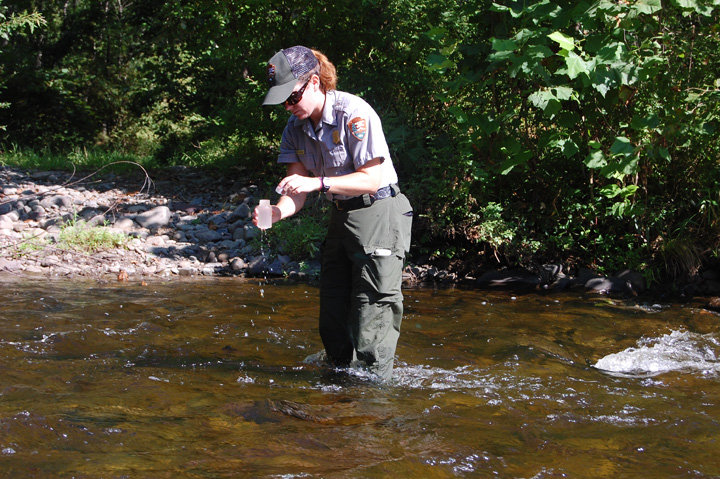
For two decades, the SRMP has been underway. A long-standing partnership between the Delaware River Basin Commission (DRBC) and the National Park Service (NPS), the SRMP is responsible for monitoring water quality in the Special Protection Waters (SPW) of the Upper Delaware Scenic and Recreational River (UDSRR), the Delaware Water Gap National Recreation Area (DWGNRA), and the Lower Delaware Scenic and Recreational River.
These regions cover approximately 200 miles of the non-tidal Delaware River and selected boundary locations within the 6,780 square mile drainage area.
The labor intensive process involves collecting water samples biweekly, Monday through Wednesday at 20 sites on the main stem of the Delaware River and some major tributaries from May through September over varying flow conditions, seasons and times of day. At each site, samples are gathered from the sides and middle of the waterway.
Some of the sites being monitored are at the Barryville and Pond Eddy bridges, Mongaup and Lackawaxen rivers and Shohola Creek. Careful practices are employed to eliminate contamination from site to site or within the lab.
Sample processing begins in the field with notations on water and air temperature, dissolved oxygen, pH and conductivity, then continues back at the NPS lab in Milanville, PA later that day. Some samples are delivered to a contracted lab which performs tests for e coli and enterococcus. Other bottles are packed into coolers and shipped overnight to the Academy of Natural Sciences in Philadelphia, PA.
“We’re shipping approximately 200 pounds of water for the purpose of evaluating things like nutrients, phosphate, nitrate, nitrite, ortho-phosphate, total dissolved solids, total suspended solids, chloride and more,” said NPS biologist Jamie Myers.
Samples processed at the NPS lab are evaluated for turbidity and processed utilizing a membrane filtration method to track levels of fecal coliform bacteria. Tests performed in late August showed typical results, but following periods of rain, bacteria levels can reveal substantial increases. “Usually, the river’s pretty clean, but during these kinds of run-off events, when the river is high and muddy, you probably don’t want to swim in it,” said Hamilton as he peered at Petri dishes pocked with fecal coliform bacteria.
As for the cause of the bacterial rise, Hamilton said it’s not easy to identify, as there are often multiple sources. “We haven’t done a lot of source tracking,” said Hamilton. “You have a watershed with a large land base and you get runoff all throughout it. In the past, we’ve identified problems with sewage treatment plants. Currently, I don’t think we have a problem with any one-point-source discharge. It’s just land use in general.”
Hamilton added that source tracking could be on the horizon, and would require additional funding. “For the most part, the river is pretty clean and good for recreation,” said Hamilton.
The long-term effort is funded by the DRBC, which developed the original protocol for the program. NPS units in the UDSRR and the DWGNRA are both participating.
“This program is an anti-degradation program meant to keep tabs on the watershed and the tributaries,” said Myers. “We’re looking for potential changes in water quality by doing the sampling on such a continuous basis. Because the water quality here is so exceptional, this program was designed to make sure it stays that way.”
As for the value of this 20-year data, which is being stored in an EPA database, Hamilton said, “Because of the data that was collected and the existing water quality that was defined for the Delaware River, the DRBC was able to implement special protection waters regulations and they defined an existing water quality that they want to have maintained here. Because we have SPW regulations for the non-tidal Delaware for the entire length of 197 miles, from Hancock to Trenton, the DRBC can step up and exert some authority over natural gas development, water use and disposal to protect water into the future.”
A concurrent NPS/United States Geological Survey Upper Delaware study is gathering complementary information to that of the SRMP. Learn more in this ongoing series.


Comments
No comments on this item Please log in to comment by clicking here